Showing posts with label world heritage sites. Show all posts

Monday, December 24, 2012

Nilgiri Mountain Railway, Tamil Nadu, India

Image

The Nilgiri Mountain Railway is a railway in Tamil NaduIndia, built by the British in 1908, and was initially operated by the Madras Railway. The railway still relies on its fleet of steam locomotives. NMR comes under the jurisdiction of the newly formed Salem Division. In July 2005, UNESCO added the Nilgiri Mountain Railway as an extension to theWorld Heritage Site of Darjeeling Himalayan Railway, the site then became known as "Mountain Railways of India."[3] After it satisfied the necessary criteria, thus forcing abandonment of the modernisation plans. For the past several years diesel locomotives have taken over from steam on the section between Coonoor and Udhagamandalam. Local people and tourists have led a demand for steam locos to once again haul this section. The famous Hindi song Chaiyya Chaiyya from the film "Dil Se" featuring Shahrukh Khanwas shot on the roof top of NMR.

Image

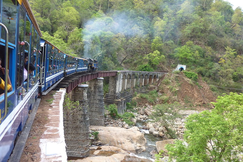
The 'Nilagiri Passenger' train covers a distance of 26 mi (41.8 km), travels through 208 curves, 16 tunnels, and 250 bridges. The uphill journey takes around 290 minutes (4.8 hours), and the downhill journey takes 215 minutes (3.6 hours) It has the steepest track in Asia with a maximum gradient of 8.33%.

Mettupalayam Station
Mettupalayam(Coimbatore) - 0 km (0 mi), 1,069 ft (325.8 m) above sea level - Junction with the 5 ft 6 in (1,676 mm) (Indian Gauge) line from Coimbatore city railway station. Passengers cross the platform to board the Nilagiri Passenger train (NMR). There is a small locomotive shed here and also the carriage workshops for the line.

Leaving Mettupalayum, the line is adhesion worked and actually drops for a short distance before crossing the Bhavani River, after which it starts to climb gently.
Kallar Station
Kallar - 8 km (5 mi), 1,260 ft (384 m) - Closed as a passenger station, this is where the rack rail begins. As the train leaves the station, the gradient is 1 in 12 (8.33%).

Adderly Station
Adderly - 13 km (8.1 mi), 2,390 ft (728.5 m) - Closed as a passenger station but is still a water stop.

Hillgrove Station
Hillgrove - 18 km (11.2 mi), 3,580 ft (1,091.2 m) - Block post and water stop, also has refreshments for passengers.

Runneymede Station
Runneymede - 21 km (13 mi), 4,612 ft (1,405.7 m) - Closed as a passenger station but is still a water stop.

Kateri Road Station
Kateri Road - 25 km (15.5 mi), 5,070 ft (1,545.3 m) - Closed as a passenger station, trains do not stop here.

Coonoor Station
Coonoor - 28 km (17.4 mi), 5,616 ft (1,711.8 m) - main intermediate station on the line at site of the locomotive workshops as well as the top end of the rack rail. Trains must reverse a short distance before continuing their climb to Ooty. It is normal for the locomotive to be changed here with diesel traction, being normal for all trains to Ooty.

Wellington Station
Wellington - 29 km (18 mi), 5,804 ft (1,769.1 m)

Aruvankadu Station
Aruvankadu - 32 km (19.9 mi), 6,144 ft (1,872.7 m)

Ketti Station
Ketti - 38 km (23.6 mi), 6,864 ft (2,092.1 m)
The Nilgiri Passenger at Ketti Railway Station

Lovedale Station
Lovedale - 42 km (26.1 mi), 7,000 ft (2,133.6 m)
Lovedale railway station

From a short distance before Lovedale, the line descends into Ooty.


Udhagamandalam Station
Ooty - 46 km (28.6 mi), 7,228 ft (2,203.1 m).


Tuesday, December 11, 2012

Giant's Causeway, Northern Ireland

Giant's Causeway, Northern Ireland

The Giant's Causeway is an area of about 40,000 interlocking basalt columns, the result of an ancient volcanic eruption. It is located in County Antrim on the northeast coast of Northern Ireland, about three miles (4.8 km) northeast of the town of Bushmills. It was declared a World Heritage Site by UNESCO in 1986, and a National Nature Reserve in 1987 by the Department of the Environment for Northern Ireland. In a 2005 poll of Radio Times readers, the Giant's Causeway was named as the fourth greatest natural wonder in the United Kingdom. The tops of the columns form stepping stones that lead from the cliff foot and disappear under the sea. Most of the columns are hexagonal, although there are also some with four, five, seven or eight sides. The tallest are about 12 metres (39 ft) high, and the solidified lava in the cliffs is 28 metres thick in places.
The Giant's Causeway is today owned and managed by the National Trust and it is the most popular tourist attraction in Northern Ireland.